South Asia
Sri Lanka El Niño 2026 outlook
Warmer than average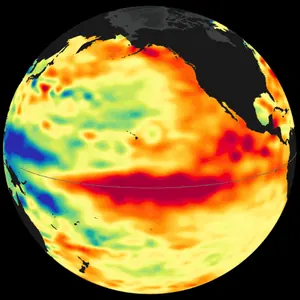
Seasonal outlook
September to November 2026
Likely warmer than usual
The European seasonal forecast model expects Sri Lanka to average about 1.2°C warmer than usual for this time of year.
Estimated chance of each outcome. With no forecast signal, each would be about 1 in 3.
Technical details
- Model: ECMWF SEAS5 (system 51) ensemble mean, from the Copernicus Climate Data Store.
- 2 m air temperature anomaly: +1.22°C, averaged over September to November 2026, relative to the model's 1993 to 2016 average.
- Taken at the model grid point nearest 7.87, 80.77, so it represents that area rather than the whole country.
- Chances (cooler / about usual / warmer): 21% / 21% / 58%. Estimated by Nino Tracker from the size of the anomaly, because the ensemble mean product does not include the model's own odds.
- Confidence is set by the anomaly's size: under 0.5°C low, 0.5 to 1°C moderate, 1°C or more high.
El Niño right now
Strong El Niño
El Niño is a natural warming of the central and eastern tropical Pacific Ocean that shifts weather patterns around the world. Over June to August 2026, sea temperatures there averaged about 1.8°C above normal, which counts as a strong event.
Technical details
- Oceanic Niño Index (ONI): +1.80 for JJA 2026. It is the 3-month average sea surface temperature anomaly in the Niño 3.4 region (5°N to 5°S, 120°W to 170°W), from NOAA.
- El Niño conditions are +0.5°C or more, La Niña −0.5°C or less, sustained for five overlapping 3-month seasons. Strength: weak 0.5 to 0.9, moderate 1.0 to 1.4, strong 1.5 to 1.9, very strong 2.0 or more.
- NOAA now uses a relative version of this index (RONI) for official monitoring. The ONI is still published each month.
- Last updated Sep 23, 2026, 7:38 PM UTC.
Upcoming 7 Days
Across these 4 cities, it averaged 26.2°, about the same as this week's forecast of 26.2°.
Nino Tracker updates weather data two times a day.
El Niño and Sri Lanka: common questions
How will El Niño affect Sri Lanka in 2026?
The European seasonal forecast model expects Sri Lanka to average about 1.2°C warmer than usual for this time of year. The forecast covers September to November 2026. A strong signal. Outcomes usually follow it, but not always.
How does El Niño usually affect Sri Lanka?
Typical effects of past El Niño events in Sri Lanka: hotter overall, weaker southwest monsoon, wetter October to December. Every event is different, so these are tendencies rather than guarantees.
How does La Niña affect Sri Lanka?
Typical effects of past La Niña events in Sri Lanka: slightly cooler, with rainfall often below normal from October to December. La Niña often pushes weather roughly the opposite way to El Niño.
What is the weather forecast for Sri Lanka this week?
Over the next 7 days, forecast lows and highs are: Colombo 24 to 29°C, Kandy 21 to 29°C, Jaffna 28 to 31°C and Galle 24 to 29°C. Across these cities the average is 26.2°C. That is about the same as the same week last year (26.2°C).
Is El Niño happening right now?
El Niño is a natural warming of the central and eastern tropical Pacific Ocean that shifts weather patterns around the world. Over June to August 2026, sea temperatures there averaged about 1.8°C above normal, which counts as a strong event. El Niño is strengthening, with a greater than 90% chance of a very strong event during the Northern Hemisphere fall and winter 2026-27.