See how El Niño could change your weather
Niño Tracker follows El Niño and La Niña, the Pacific Ocean patterns that shift rain and temperatures around the world. It turns official forecasts from NOAA and Europe's Copernicus service into plain-English outlooks for 25 countries, updated twice a day.
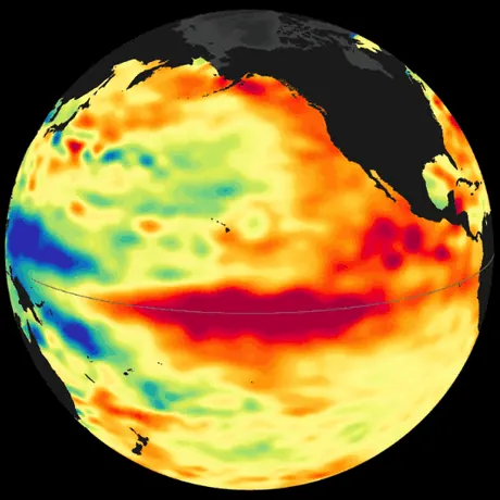
Right now in the Pacific
El Niño is under way
The central tropical Pacific is about 2.2°C warmer than normal. That is enough to shift rainfall and temperatures in many countries.
NOAA's outlook: El Niño continues to strengthen, with a strong-to-very strong El Niño likely through January-March 2027 (remaining greater than an 83% chance).
Technical details
- Oceanic Niño Index (ONI): +2.16 for JAS 2026 (July to September 2026). It is the 3-month average sea surface temperature anomaly in the Niño 3.4 region (5°N to 5°S, 120°W to 170°W). NOAA CPC
- El Niño is +0.5°C or more and La Niña −0.5°C or less, held for five overlapping 3-month seasons. Strength: weak 0.5 to 0.9, moderate 1.0 to 1.4, strong 1.5 to 1.9, very strong 2.0 or more.
- Outlook text is the synopsis of NOAA's monthly ENSO Diagnostic Discussion.
- Country count uses the seasonal temperature outlooks below (ECMWF SEAS5 via Copernicus where available). Data refreshes at 00:00 and 12:00 UTC.
Countries by region
North America
 United StatesNear average
Expected to stay close to usual, Oct to Dec.
 CanadaWarmer than average
Expected to average about 2.5°C warmer than usual, Oct to Dec.
 MexicoCooler than average
Expected to average about 0.5°C cooler than usual, Oct to Dec.
South America
 PeruWarmer than average
Expected to average about 1.7°C warmer than usual, Oct to Dec.
 EcuadorWarmer than average
Expected to average about 1.3°C warmer than usual, Oct to Dec.
 ColombiaWarmer than average
Expected to average about 1.7°C warmer than usual, Oct to Dec.
 BrazilWarmer than average
Expected to average about 2.1°C warmer than usual, Oct to Dec.
 ArgentinaCooler than average
Expected to average about 1.7°C cooler than usual, Oct to Dec.
Southeast Asia
 IndonesiaWarmer than average
Expected to average about 1.1°C warmer than usual, Oct to Dec.
 PhilippinesWarmer than average
Expected to average about 1.0°C warmer than usual, Oct to Dec.
 VietnamWarmer than average
Expected to average about 1.5°C warmer than usual, Oct to Dec.
Oceania
 AustraliaNear average
Expected to stay close to usual, Oct to Dec.
 Papua New GuineaWarmer than average
Expected to average about 0.8°C warmer than usual, Oct to Dec.
 New ZealandWarmer than average
Expected to average about 0.3°C warmer than usual, Oct to Dec.
South Asia
 IndiaWarmer than average
Expected to average about 2.2°C warmer than usual, Oct to Dec.
 Sri LankaWarmer than average
Expected to average about 1.2°C warmer than usual, Oct to Dec.
East Africa
 KenyaWarmer than average
Expected to average about 0.9°C warmer than usual, Oct to Dec.
 EthiopiaWarmer than average
Expected to average about 1.4°C warmer than usual, Oct to Dec.
 SomaliaWarmer than average
Expected to average about 0.3°C warmer than usual, Oct to Dec.
 TanzaniaWarmer than average
Expected to average about 0.9°C warmer than usual, Oct to Dec.
Southern Africa
 South AfricaWarmer than average
Expected to average about 1.9°C warmer than usual, Oct to Dec.
 ZimbabweNear average
Expected to stay close to usual, Oct to Dec.
 MozambiqueWarmer than average
Expected to average about 0.5°C warmer than usual, Oct to Dec.
East Asia
 JapanWarmer than average
Expected to average about 1.6°C warmer than usual, Oct to Dec.
 ChinaNear average
Expected to stay close to usual, Oct to Dec.
El Niño questions, answered
Is El Niño happening in 2026?
Yes. As of October 23, 2026, very strong El Niño conditions are present in the tropical Pacific. El Niño continues to strengthen, with a strong-to-very strong El Niño likely through January-March 2027 (remaining greater than an 83% chance).
What is El Niño?
El Niño is a natural climate pattern in which the surface of the central and eastern tropical Pacific Ocean becomes warmer than normal. The warm water moves where tropical storms and rain form, which shifts winds, temperatures and rainfall around the world. It is the warm phase of the El Niño-Southern Oscillation (ENSO). Episodes usually last 9 to 12 months, tend to peak around December, and return every 2 to 7 years.
What is La Niña?
La Niña is the opposite, cool phase of ENSO: the central and eastern tropical Pacific is cooler than normal. It often pushes weather in roughly the opposite direction to El Niño, for example wetter conditions in Indonesia and Australia and drier conditions in parts of the southern United States.
How strong is El Niño right now?
NOAA measures El Niño and La Niña with the Oceanic Niño Index (ONI), the 3-month average sea surface temperature anomaly in the Niño 3.4 region of the central tropical Pacific. An El Niño needs the ONI at +0.5°C or more, and a La Niña at −0.5°C or less, held for five overlapping 3-month seasons. By size, events are weak (0.5 to 0.9), moderate (1.0 to 1.4), strong (1.5 to 1.9) or very strong (2.0 or more). The latest ONI is +2.2°C for July to September 2026, a very strong El Niño.
Which countries will be warmer than usual in 2026?
Of the 25 countries tracked here, the seasonal outlook leans warmer than usual for Canada, Peru, Ecuador, Colombia, Brazil, Indonesia, Philippines, Vietnam, Papua New Guinea, New Zealand, India, Sri Lanka, Kenya, Ethiopia, Somalia, Tanzania, South Africa, Mozambique and Japan. It leans cooler for Mexico and Argentina. Each country page explains the outlook, how confident it is, and how El Niño has affected that country before.
How accurate are these outlooks?
They are probabilities, not exact forecasts. A lean toward warmer than usual means warmer is the most likely outcome over the season as a whole, not that every week will be warm. Seasonal outlooks come from the European ECMWF model via Copernicus, which is issued once a month; the site checks all sources and rebuilds twice a day. For day-to-day weather, use a local forecast.